Back يونغ ستريت Arabic Yonge Street Catalan شەقامی یانگ CKB Yonge Street German Yonge Street Spanish Yonge Street Basque خیابان یانگ Persian Yonge Street Finnish Rue Yonge French Յանգ Սթրիտ Armenian
This article needs additional citations for verification. (June 2020) |
 | |||||||||
|---|---|---|---|---|---|---|---|---|---|
| York Regional Roads 1 / 51 | |||||||||
 Yonge Street (Toronto/York section) | |||||||||
| Maintained by | City of Toronto York Region Town of East Gwillimbury | ||||||||
| Location | Toronto Vaughan Markham Richmond Hill Aurora Newmarket East Gwillimbury | ||||||||
| South end | Queens Quay in Toronto | ||||||||
| Major junctions | King Street Queen Street Dundas Street Bloor Street St. Clair Avenue Eglinton Avenue Lawrence Avenue Wilson Avenue / York Mills Road Sheppard Avenue Finch Avenue Steeles Avenue | ||||||||
| North end | Holland River | ||||||||
| Construction | |||||||||
| Inauguration | 1794[1] | ||||||||
| |||||||||
| Simcoe County Road 4 | |||||||||
 Yonge Street (Simcoe section) | |||||||||
| Maintained by | Simcoe County City of Barrie | ||||||||
| Length | 30 km (19 mi)[3] | ||||||||
| Location | Barrie Bradford West Gwillimbury Innisfil Simcoe | ||||||||
| South end | 8th Line in Bradford (continues south as Barrie Street) | ||||||||
| Major junctions | |||||||||
| North end | Former Canadian National rail spur in Barrie (Continues as Burton Avenue) | ||||||||
| Construction | |||||||||
| Inauguration | 1827 | ||||||||
| |||||||||
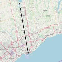
Yonge Street (/jʌŋ/ YUNG) is a major arterial route in the Canadian province of Ontario connecting the shores of Lake Ontario in Toronto to Lake Simcoe, a gateway to the Upper Great Lakes. Ontario's first colonial administrator, John Graves Simcoe, named the street for his friend Sir George Yonge, an expert on ancient Roman roads.
Once the southernmost leg of provincial Highway 11, linking the provincial capital with northern Ontario, Yonge Street has been referred to as "Main Street Ontario". Until 1999, the Guinness Book of World Records repeated the popular misconception that Yonge Street was 1,896 km (1,178 mi)[4] long, making it the longest street in the world; this was due to a conflation of Yonge Street with the rest of Ontario's Highway 11. The street (including the Bradford-to-Barrie extension) is only 86 kilometres (53 mi) long.[2][3] Due to provincial downgrading in the 1990s, no section of Yonge Street is marked as a provincial highway.
Its construction has been designated as an Event of National Historic Significance in Canada.[5] Yonge Street was integral to the original planning and settlement of western Upper Canada in the 1790s, forming the basis of the concession roads in Ontario today. In Toronto and York Region, Yonge Street is the north–south baseline from which street numbering is reckoned east and west. The eastern branch of the subway Line 1 Yonge–University serves nearly the entire length of the street in Toronto; it serves as the spine of the Toronto subway system, linking to suburban commuter systems such as the Viva Blue BRT. The street is a commercial main thoroughfare rather than a ceremonial one, with the Downtown Yonge shopping and entertainment district containing landmarks such as the Eaton Centre and Yonge–Dundas Square.
- ^ the Historical Committee (1984). "Main Street, Ontario". From Footpaths to Freeways. Ontario Ministry of Transportation and Communications. p. 23. ISBN 0-7743-9388-2.
- ^ a b "Toronto Neighborhoods". Boldts.net. Archived from the original on 2019-08-15. Retrieved 2021-09-15.
- ^ a b Google (March 21, 2018). "Yonge Street route Simcoe County & Barrie" (Map). Google Maps. Google. Retrieved March 21, 2018.
- ^ Young, Mark C. (1999). Guinness Book of World Records. Bantam. ISBN 0-553-58075-2. Archived from the original on May 5, 2010. Retrieved February 16, 2010.
- ^ Construction of Yonge Street National Historic Event – Directory of Designations of National Historic Significance of Canada
© MMXXIII Rich X Search. We shall prevail. All rights reserved. Rich X Search