Back ولاية تيارت Arabic Provincia de Tiaret AST Tiaret vilayəti Azerbaijani تیارت اوستانی AZB Тыярэт (правінцыя) Byelorussian Тыярэт (вілает) BE-X-OLD Тиарет (област) Bulgarian Província de Tiaret Catalan Wilaya de Tiaret CEB Tiaret (provins) Danish
Tiaret Province
ولاية تيارت | |
|---|---|
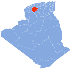
 Map of Algeria highlighting Tiaret | |
| Coordinates: 35°23′N 01°20′E / 35.383°N 1.333°E | |
| Country | |
| Capital | Tiaret |
| Government | |
| • Wāli | Saïd Khalil |
| Area | |
• Total | 20,673 km2 (7,982 sq mi) |
| Population (2008)[1] | |
• Total | 842,063 |
| • Density | 41/km2 (110/sq mi) |
| Time zone | UTC+01 (CET) |
| Area Code | +213 (0) 46 |
| ISO 3166 code | DZ-14 |
| Districts | 14 |
| Municipalities | 42 |
You can help expand this article with text translated from the corresponding article in Arabic. Click [show] for important translation instructions.
|
Tiaret (Arabic: ولاية تيارت) is a province (wilaya) of Algeria. The capital is Tiaret.
The National Stud Farm of Chaouchaoua is located in the province of Tiaret.
- ^ Office National des Statistiques, Recensement General de la Population et de l’Habitat 2008 Archived 2008-07-24 at the Wayback Machine Preliminary results of the 2008 population census. Accessed on 2008-07-02.
© MMXXIII Rich X Search. We shall prevail. All rights reserved. Rich X Search