Back Santa Monica State Beach CEB Santa Monicako estatu-hondartza Basque Santa Monica State Beach French Pantai Negara Bagian Santa Monica ID Santa Monica State Beach Polish 圣莫尼卡海滩 Chinese
| Santa Monica State Beach | |
|---|---|
 | |
| Location | Los Angeles County, California |
| Nearest city | Santa Monica |
| Coordinates | 34°0′54″N 118°30′6″W / 34.01500°N 118.50167°W |
| Governing body | California Department of Parks and Recreation |

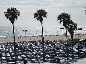
Santa Monica State Beach is a California State Park operated by the city of Santa Monica.[1][2]
The beach is located along Pacific Coast Highway. It is 3.5 miles (5.6 km) long and has parks, picnic areas, playgrounds, restrooms, as well as staffed lifeguard stations, the Muscle Beach, bike rentals, concessions, a few hotels, a bike path, and wooden pathways for beachgoers with disabilities.[3] Visitor activities include volleyball, surfing, stand up paddleboarding, and swimming.[1] Smoking at the beach is prohibited.[4]
- ^ a b "California State Parks: Santa Monica State Beach". Archived from the original on February 22, 2008.
- ^ "City of Santa Monica official beach web site". Archived from the original on October 2, 2013. Retrieved September 29, 2013.
- ^ "Santa Monica Beach". Archived from the original on May 9, 2008.
- ^ "Santa Monica Beach and Bike Path Rules". Archived from the original on October 2, 2013. Retrieved September 29, 2013.
© MMXXIII Rich X Search. We shall prevail. All rights reserved. Rich X Search

