Back محافظة القنيطرة Arabic محافظة القنيطره ARZ Əl-Qüneytirə mühafəzəsi Azerbaijani قنیطره اوستانی AZB Кунейтра (мухафаза) Bulgarian Quneitra Governorate CEB پارێزگای قونەیترە CKB Guvernorát Kunejtra Czech Quneitra Danish Gouvernement al-Quneitra German
Quneitra Governorate
مُحافظة القنيطرة (Arabic) | |
|---|---|
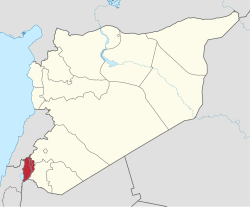
 Map of Syria with Quneitra Governorate highlighted Syrian-held areas are on the right of the hatched UNDOF buffer zone; the rest is Israeli-occupied Golan Heights. | |
| Coordinates (Quneitra): 33°07′34″N 35°49′26″E / 33.126°N 35.824°E | |
| Country | |
| Control | |
| Capital | Quneitra (de jure) Madinat al-Salam (de facto) |
| Government | |
| • Governor | Ahmed al-Dalati |
| Area | |
• Total | 1,200 km2 (500 sq mi) |
| Estimates range between 685 km2 and 1,861 km2 | |
| Population (2021)[2] | |
• Total | 105,124 |
| • Density | 88/km2 (230/sq mi) |
| Time zones | UTC+2 (EET) |
| • Summer (DST) | UTC+3 (EEST) |
| UTC+3 (Arabia Standard Time) | |
| ISO 3166 code | SY-QU |
| Main language(s) | Arabic |
Quneitra Governorate[a] is one of the fourteen governorates (provinces) of Syria. It is situated in southern Syria, notable for the location of the Golan Heights. The governorate borders the countries of Lebanon, Jordan and Israel, and the Syrian governorates of Daraa and Rif Dimashq. Its area varies, according to different sources, from 685 km2[3] to 1,861 km2.[4] The governorate had a population of 87,000 at the 2010 estimate.[3] The nominal capital is the now abandoned city of Quneitra, destroyed by Israel before their withdrawal in June 1974 in the aftermath of the Yom Kippur War; since 1986, the de facto capital is Madinat al-Salam.
During the Syrian Civil War, most of the portions of the governorate that are not held by Israel were taken by various opposition and Jihadist forces. In the summer of 2018, the rebel-held areas in the governorate were retaken by the Syrian government.
Following the 2024 Syrian opposition offensives, the resurgent Southern Front declared full control over the governorate (excluding Israeli-controlled areas). Later, Israel advanced its troops into the buffer zone amid reports of artillery strikes on local villages.
- ^ "إعلام عبري: دخول بري "إسرائيلي" مع دبابات إلى القنيطرة السورية". factjo.com. 2024-12-08. Retrieved 2024-12-08.
- ^ “Quneitra.” European Union Agency for Asylum, 2021. Link.
- ^ a b "Syria: Governorates, Major Cities & Localities – Population Statistics, Maps, Charts, Weather and Web Information". www.citypopulation.de. Archived from the original on 2015-09-07. Retrieved 2006-10-14.
- ^ "Syria Provinces". www.statoids.com. Archived from the original on 2015-07-13. Retrieved 2006-10-14.
Cite error: There are <ref group=lower-alpha> tags or {{efn}} templates on this page, but the references will not show without a {{reflist|group=lower-alpha}} template or {{notelist}} template (see the help page).
© MMXXIII Rich X Search. We shall prevail. All rights reserved. Rich X Search