Back Navassa Afrikaans Navassa ALS Nafāssa-Īeg ANG جزيرة نافاسا Arabic جزيره نافاسا ARZ Navassa adası Azerbaijani Navassa BAR Наваса Byelorussian Наваса BE-X-OLD Наваса Bulgarian
Navassa Island
| |
|---|---|
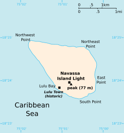
 Map of Navassa Island | |
| Coordinates: 18°24′10″N 75°0′45″W / 18.40278°N 75.01250°W | |
| Administered by | |
| Status | Unorganized unincorporated territory |
| Territory | United States Minor Outlying Islands |
| Claimed by | |
| Claimed by the United States | September 19, 1857 |
| Claimed by Haiti | 1697 (implicitly) 1874 (explicitly) |
| Government | |
| • Body | Caribbean Islands National Wildlife Refuge Complex (under the authority of the U.S. Fish and Wildlife Service) |
| • Project Leader | Silmarie Padrón |
| Area | |
| • Land | 5 km2 (2.1 sq mi) |
| Highest elevation | 85 m (279 ft) |
| Lowest elevation | 0 m (0 ft) |
| Population | 0 |
| Time zone | UTC-5:00 (Eastern Time Zone) |
| APO / ZIP Code | 96898 |
| ISO 3166 code | UM-76 |

Navassa Island (/nəˈvæsə/; Haitian Creole: Lanavaz; French: Île de la Navasse, sometimes la Navase) is an uninhabited island in the Windward Passage of the Caribbean Sea. Located east of Jamaica, south of Cuba, and 40 nautical miles (74 km; 46 mi) west of Jérémie on the Tiburon Peninsula of Haiti, it is subject to an ongoing territorial dispute between Haiti and the United States, which administers the island through the U.S. Fish and Wildlife Service.[1]
The U.S. has claimed the island as an appurtenance since 1857, based on the Guano Islands Act of 1856.[2][3] Haiti's claim over Navassa goes back to the Treaty of Ryswick in 1697 that recognized French, rather than Spanish, control of the western portion of the island of Hispaniola and other specifically named nearby islands.[4] However, there was no mention of Navassa in the treaty detailing terms.[5] Haiti's 1801 constitution claimed several nearby islands by name, among which Navassa was not listed, but also laid claim to "other adjacent islands", which Haiti maintains included Navassa. The U.S. claim to the island, first made in 1857, asserts that Navassa was not included among the unnamed "other adjacent islands" in the 1801 Haitian Constitution. Since the Haitian Constitution of 1874, Haiti has explicitly named "la Navase" as one of the territories it claims. It maintains that it has continuously been claimed as part of Haiti since 1801.[6][7][8][9]
- ^ Cite error: The named reference
U.S. Government Printing Officewas invoked but never defined (see the help page). - ^ Blocher, Joseph; Gulati, Mitu (2022). "Navassa: Property, Sovereignty, and the Law of the Territories". Yale Law Journal. 131 (8): Introduction.
- ^ "Navassa Island: The U.S.'s 160-year Forgotten Tragedy | History News Network". historynewsnetwork.org. Retrieved May 14, 2019.
- ^ Spadi, Fabio. "NAVASSA: LEGAL NIGHTMARES IN A BIOLOGICAL HEAVEN?". IBRU Boundary and Security Bulletin, Autumn 2001. p. 116. Archived from the original on December 1, 2017. Retrieved November 22, 2017.
- ^ "Navassa: America's Forgotten Caribbean Island". The Institute of World Politics. February 10, 2021. Retrieved December 6, 2022.
- ^ Constitution de 1874. Port-au-Prince: Haiti.
- ^ An America Territory in Haiti, Posted September 29, 2011, CNN iReport
- ^ Serge Bellegarde (October 1998). "Navassa Island: Haiti and the U.S. – A Matter of History and Geography". windowsonhaiti.com. Archived from the original on October 29, 2007. Retrieved February 6, 2008.
© MMXXIII Rich X Search. We shall prevail. All rights reserved. Rich X Search

