Back Laâyoune Afrikaans L'Aaiún AN العيون (مدينة) Arabic لعيون ARY العيون ARZ L'Aaiún AST Laayoune AVK Əl-Əyun Azerbaijani العیون AZB Эль-Аюн Byelorussian
Laayoune
العيون (Arabic) El Aaiún | |
|---|---|
City | |
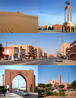
 Left to right, top to bottom: Footprints on the sand, Place Mechouar, Street, Monumental Arch, Laayoune Cathedral | |
| Coordinates: 27°09′00″N 13°11′56″W / 27.15000°N 13.19889°W | |
| Non-self-governing territory | Western Sahara |
| Claimed by | |
| Controlled by | |
| Region | Laâyoune-Sakia El Hamra |
| Province | Laâyoune |
| Settled | 1934 |
| Founded | 1938 |
| Founded by | Antonio de Oro |
| Area | |
• Total | 247.8 km2 (95.68 sq mi) |
| Population (2014)[1] | |
• Total | 217,732 |
| • Density | 880/km2 (2,300/sq mi) |
| Time zone | UTC+01:00 (West Africa Time) |
| • Summer (DST) | (Not Observed) |
Laayoune[note 1] or El Aaiún[note 2] (Arabic: العيون, al-ʕuyūn [alʕujuːn], Hassaniyya: [ˈləʕjuːn] ⓘ, lit. 'The Springs') is the largest city of the disputed territory of Western Sahara, with a population of 271,344 in 2023.[7] The city is the de jure capital of the Sahrawi Arab Democratic Republic, though it is under de facto Moroccan administration as occupied territory. The modern city is thought to have been founded by the Spanish captain Antonio de Oro in 1938.[8] From 1958, it became the administrative capital of the Spanish Sahara, administered by the Governor General of Spanish West Africa.[9]
In 2023, Laayoune is the capital of the Laâyoune-Sakia El Hamra region administered by Morocco, it is still under the supervision of MINURSO, a UN mission.
The town is located south of the dry river of Saguia el-Hamra, where the old lower town constructed by Spanish colonists is located.[10] The St. Francis of Assisi Cathedral was constructed during the Spanish period and is still active with a few Catholic missionaries.
- ^ "Population Légale des Régions, Provinces, Préfectures, Municipalités, Arrondissements et Communes du Royaume D'Après Les Résultats du 2014" (in Arabic and French). High Commission for Planning, Morocco. 8 April 2015. Retrieved 29 September 2017.
- ^ "Laayoune". Lexico UK English Dictionary. Oxford University Press. Archived from the original on 2020-03-22.
- ^ a b "Laayoune". Merriam-Webster.com Dictionary. Merriam-Webster. Retrieved 17 August 2019.
- ^ "Laâyoune". Collins English Dictionary. HarperCollins. Retrieved 17 August 2019.
- ^ "el-Aaiún". Lexico UK English Dictionary UK English Dictionary. Oxford University Press.[dead link]
- ^ "El Aaiún". Collins English Dictionary. HarperCollins. Retrieved 17 August 2019.
- ^ "Population totale". siredd.environnement.gov.ma. Retrieved 2023-08-23.
- ^ Francisco López Barrios (2005-01-23). "El Lawrence de Arabia Español" (in Spanish). El Mundo. Retrieved 2013-02-11.
- ^ Norris, H. T. (1964). "The Wind of Change in the Western Sahara". The Geographical Journal. 130 (1): 1–14. doi:10.2307/1794260. ISSN 0016-7398. JSTOR 1794260.
- ^ Deubel, Tara F.; Boum, Aomar (2019). "The Rise of a Saharan City". Routledge Handbook on Middle East Cities. Abingdon: Routledge. doi:10.4324/9781315625164-18. ISBN 9781138650749.
Cite error: There are <ref group=note> tags on this page, but the references will not show without a {{reflist|group=note}} template (see the help page).
© MMXXIII Rich X Search. We shall prevail. All rights reserved. Rich X Search

