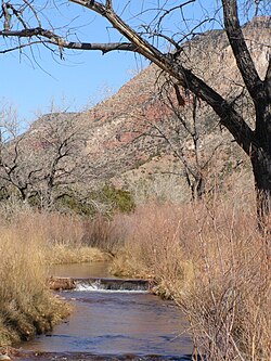
| Jemez River | |
|---|---|
 Jemez River, downstream from Jemez Pueblo, November 2008 | |
| Location | |
| Country | United States |
| State | New Mexico |
| County | Sandoval |
| Physical characteristics | |
| Source | Confluence of San Antonio Creek and East Fork Jemez River |
| • location | Jemez Mountains |
| • coordinates | 35°51′57″N 106°38′21″W / 35.86583°N 106.63917°W[1] |
| Mouth | Rio Grande |
• coordinates | 35°22′9″N 106°30′52″W / 35.36917°N 106.51444°W[1] |
| Length | 80 mi (130 km)[2] |
| Basin size | 1,038 sq mi (2,690 km2)[3] |
| Discharge | |
| • location | USGS gage 08329000, 2 miles above mouth[3] |
| • average | 59.5 cu ft/s (1.68 m3/s)[3] |
| • minimum | 0 cu ft/s (0 m3/s) |
| • maximum | 3,640 cu ft/s (103 m3/s) |
| Official name | Jemez (East Fork) |
| Type | Wild, Scenic, Recreational |
| Designated | June 6, 1990 |
The Jemez River is a tributary of the Rio Grande in eastern Sandoval County, New Mexico, United States.
- ^ a b U.S. Geological Survey Geographic Names Information System: Jemez River
- ^ Cite error: The named reference
gearthwas invoked but never defined (see the help page). - ^ a b c "Water resources data for the United States, Water Year 2009; gage 08329000, Jemez River below Jemez Canyon Dam, NM" (PDF). USGS. Retrieved 20 July 2010.
© MMXXIII Rich X Search. We shall prevail. All rights reserved. Rich X Search

