Back दक्खिन अमेरिका के भूगोल Bihari দক্ষিণ আমেরিকার ভূগোল Bengali/Bangla Physische Geographie Südamerikas German Geografía de América del Sur Spanish جغرافیای آمریکای جنوبی Persian Géographie de l'Amérique du Sud French Dél-Amerika földrajza Hungarian 남아메리카의 지리 Korean Geografia Ameryki Południowej Polish Geografia da América do Sul Portuguese


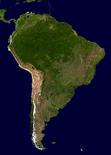
The geography of South America contains many diverse regions and climates. Geographically, South America is generally considered a continent forming the southern portion of the landmass of the Americas, south and east of the Colombia–Panama border by most authorities, or south and east of the Panama Canal by some. South and North America are sometimes considered a single continent or supercontinent, while constituent regions are infrequently considered subcontinents.
South America became attached to North America only recently (geologically speaking) with the formation of the Isthmus of Panama some 3 million years ago, which resulted in the Great American Interchange. The Andes, likewise a comparatively young and seismically restless mountain range, runs down the western edge of the continent; the land to the east of the northern Andes is largely tropical rainforest, the vast Amazon River basin. The continent also contains drier regions such as eastern Patagonia and the extremely arid Atacama Desert.
The South American continent also includes various islands, most of which belong to countries on the continent. The Caribbean territories are grouped with North America. The South American nations that border the Caribbean Sea — Colombia and Venezuela —are also known as the Caribbean South America.
© MMXXIII Rich X Search. We shall prevail. All rights reserved. Rich X Search