Back Čtyři rohy (Kanada) Czech Four Corners (Kanada) German Four Corners (Canada) French Four Corners (Kanada) Croatian Four Corners (Canada) Italian フォー・コーナーズ (カナダ) Japanese Quatro Cantos (Canadá) Portuguese Четыре угла (Канада) Russian


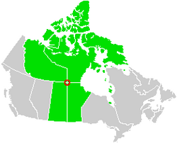
The four corners is a quadripoint near 60° N 102° W where four Canadian provinces or territories meet.[1][2] These are the provinces of Manitoba and Saskatchewan and the territories of the Northwest Territories and Nunavut.[1] It came into being with the creation of Nunavut on April 1, 1999.
- ^ a b Hill, Tony L. (2002). Canadian politics, riding by riding: an in-depth analysis of Canada's 301 federal electoral districts. Minneapolis: Prospect Park Press. p. 448. ISBN 978-0972343602. Archived from the original on August 26, 2016. Retrieved November 30, 2021.
- ^ "Nunavut". Welcome to Canada. Canadian Tourism Development Corporation. Archived from the original on October 19, 2013. Retrieved February 20, 2015.
© MMXXIII Rich X Search. We shall prevail. All rights reserved. Rich X Search