Back مقاطعة كولوسا (كاليفورنيا) Arabic Koluza qraflığı (Kaliforniya) Azerbaijani Colusa County, Kalifornien BAR Колуза (окръг) Bulgarian কোলুসা কাউন্টি, ক্যালিফোর্নিয়া BPY Колуза (гуо, Калифорни) CE Colusa County CEB ناوچەی کۆلوس (کالیفۆرنیا) CKB Colusa County Czech Colusa County, Califfornia Welsh
Colusa County, California | |
|---|---|
| County of Colusa | |
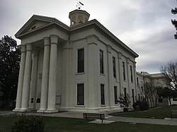
 Colusa County Courthouse | |
 Interactive map of Colusa County | |
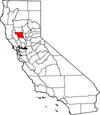
 Location in the state of California | |
| Country | United States |
| State | California |
| Region | Sacramento Valley |
| Incorporated | February 18, 1850[1] |
| Named for | Rancho Colus |
| County seat | Colusa |
| Largest city | Colusa (population) Williams (area) |
| Government | |
| • Type | Council–CAO |
| • Chair[2] | Kent S. Boes |
| • Vice Chair[3] | Gary J. Evans |
| • Board of Supervisors[4] | Supervisors
|
| • County Administrative Officer | Wendy G. Tyler |
| Area | |
| • Total | 1,156 sq mi (2,990 km2) |
| • Land | 1,151 sq mi (2,980 km2) |
| • Water | 5.6 sq mi (15 km2) |
| Highest elevation | 7,059 ft (2,152 m) |
| Population (2020) | |
| • Total | 21,839 |
| • Density | 19/sq mi (7.3/km2) |
| Time zone | UTC-8 (Pacific Time Zone) |
| • Summer (DST) | UTC-7 (Pacific Daylight Time) |
| Area code | 530 |
| Congressional district | 1st |
| Website | www |
Colusa County (/kəˈluːsə/ ) is a county located in the U.S. state of California. As of the 2020 census, the population was 21,839.[6] The county seat is Colusa.[7] It is in the northern Sacramento Valley, northwest of the state capital, Sacramento.
- ^ "Chronology". California State Association of Counties. Archived from the original on January 29, 2016. Retrieved February 6, 2015.
- ^ "District 3 | Colusa County, CA - Official Website".
- ^ "District 4 | Colusa County, CA - Official Website".
- ^ "Member & District Information | Colusa County, CA - Official Website".
- ^ "Snow Mountain". Peakbagger.com. Retrieved May 13, 2015.
- ^ "Colusa County, California". United States Census Bureau. Retrieved January 30, 2022.
- ^ "Find a County". National Association of Counties. Archived from the original on May 31, 2011. Retrieved June 7, 2011.
© MMXXIII Rich X Search. We shall prevail. All rights reserved. Rich X Search
