Back جبهة باردة Arabic Халодны фронт Byelorussian Студен атмосферен фронт Bulgarian শীতল বায়ুরেখা Bengali/Bangla Front fred Catalan Studená fronta Czech Koldfront Danish Kaltfront German Ψυχρό μέτωπο Greek Frente frío Spanish
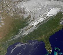
A cold front is the leading edge of a cooler mass of air at ground level that replaces a warmer mass of air and lies within a pronounced surface trough of low pressure. It often forms behind an extratropical cyclone (to the west in the Northern Hemisphere, to the east in the Southern), at the leading edge of its cold air advection pattern—known as the cyclone's dry "conveyor belt" flow. Temperature differences across the boundary can exceed 30 °C (54 °F) from one side to the other. When enough moisture is present, rain can occur along the boundary. If there is significant instability along the boundary, a narrow line of thunderstorms can form along the frontal zone. If instability is weak,[clarification needed] a broad shield of rain can move in behind the front, and evaporative cooling of the rain can increase the temperature difference across the front. Cold fronts are stronger in the fall and spring transition seasons and are weakest during the summer.


© MMXXIII Rich X Search. We shall prevail. All rights reserved. Rich X Search