| Cocklebiddy Western Australia | |
|---|---|
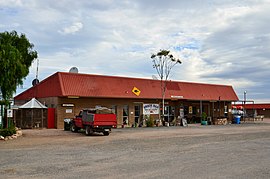
 The Wedgetail Inn, Cocklebiddy, 2017 | |
 | |
| Coordinates | 32°2′24″S 126°5′46″E / 32.04000°S 126.09611°E |
| Population | 15 (SAL 2021)[1] |
| Established | 1879 |
| Postcode(s) | 6443 |
| Area | 8,765.2 km2 (3,384.3 sq mi) |
| Location | |
| LGA(s) | Shire of Dundas |
| State electorate(s) | Eyre |
| Federal division(s) | O'Connor |
Cocklebiddy is a small roadhouse community located on the Eyre Highway in Western Australia. It is the third stop after Norseman on the journey eastwards across the Nullarbor Plain. Like other locations in the region, the site consists of little more than a roadhouse. The current business name of the roadhouse is the Wedgetail Inn and, like most other Nullarbor establishments, has access to satellite television, as well as providing caravan park and hotel-motel facilities.
It is the nearest locality to the coastal feature of Twilight Cove, which is 26 km (16 mi) to the south.[2] Cocklebiddy follows the time zone used by Eucla of UTC+8:45.[3] It is situated 284 km (176 mi) from Border Village.
- ^ Australian Bureau of Statistics (28 June 2022). "Cocklebiddy (suburb and locality)". Australian Census 2021 QuickStats. Retrieved 28 June 2022.
- ^ Murray, Ian; Hercock, Marion; Murray, Ian; Hercock, Marion (2008), Where on the coast is that?, Hesperian Press, ISBN 978-0-85905-452-2
- ^ "Forget daylight saving, this stretch of desert has its own strange little time zone". ABC News. 8 April 2019.
© MMXXIII Rich X Search. We shall prevail. All rights reserved. Rich X Search

