Back إقليم العاصمة Arabic Hövüdborqarsvaydid Azerbaijani Höfuðborgarsvæði Breton Gran Reykjavík Catalan Höfuðborgarsvæði CEB Reykjavická aglomerace Czech Reykjavík Fawr Welsh Höfuðborgarsvæðið Danish Höfuðborgarsvæðið German Περιφέρεια Πρωτεύουσας της Ισλανδίας Greek
Capital Region
Höfuðborgarsvæðið (Icelandic) | |
|---|---|
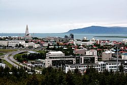
Reykjavík from Perlan Rooftops from Hallgrímskirkja Reykjavík from Hallgrímskirkja Panorama from Perlan | |
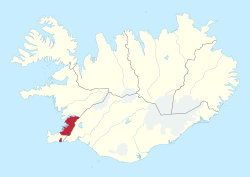
 Map of Iceland with the Capital Region highlighted | |
| Coordinates: 64°08′N 21°56′W / 64.133°N 21.933°W | |
| Country | Iceland |
| Largest town | Reykjavík |
| Area | |
• Total | 1,046 km2 (404 sq mi) |
| Population (2025)[2] | |
• Total | 249,054 |
| • Density | 238.10/km2 (616.7/sq mi) |
| Time zone | UTC+00:00 (WET) |
| ISO 3166 code | IS-1 |
The Capital Region (Icelandic: Höfuðborgarsvæðið [a]) is a region in southwestern Iceland. It is one of the two classified Nomenclature of Territorial Units for Statistics (NUTS-2) statistical regions of Iceland. The region encompasses an area of 1,046 km2 (404 sq mi), and consists of the national capital Reykjavík and six municipalities around it. Though it is much smaller than the other regions of Iceland, the region hosts about two-thirds of the population of the country.
- ^ "Náttúrufræðistofnun - Sveitarfélagasjá" [National Land Survey of Iceland]. Government of Iceland. Retrieved 19 December 2024.
- ^ "Population by regions, sex and age 1 January 1998-2025". Statistics Iceland. 1 January 2025. Retrieved 20 March 2025.
Cite error: There are <ref group=lower-alpha> tags or {{efn}} templates on this page, but the references will not show without a {{reflist|group=lower-alpha}} template or {{notelist}} template (see the help page).
© MMXXIII Rich X Search. We shall prevail. All rights reserved. Rich X Search


