Back مقاطعة كيب مي (نيو جيرسي) Arabic Keyp-Mey (dairə) Azerbaijani Cape May County, New Jersey BAR Кейп Мей (окръг, Ню Джърси) Bulgarian কেইপ মে কাউন্টি, নিউ জার্সি BPY Cape May Gông (New Jersey) CDO Кейп-Мей (гуо, Нью-Джерси) CE Cape May County CEB Cape May County, New Jersey Welsh Cape May County German
Cape May County | |
|---|---|
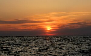
 Sunset on Sunset Beach in Lower Township in May 2009 | |
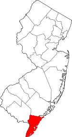
 Location within the U.S. state of New Jersey | |
 New Jersey's location within the U.S. | |
| Coordinates: 39°05′N 74°52′W / 39.08°N 74.86°W | |
| Country | |
| State | |
| Founded | 1685 |
| Named for | Cornelius Jacobsen Mey |
| Seat | Cape May Court House |
| Largest municipality | Lower Township (population) Middle Township (area) |
| Government | |
| • Commission Director | Leonard C. Desiderio (R, term ends December 31, 2024) |
| Area | |
| • Total | 620.31 sq mi (1,606.6 km2) |
| • Land | 251.52 sq mi (651.4 km2) |
| • Water | 368.79 sq mi (955.2 km2) 59.5% |
| Population | |
| • Total | 95,263 |
| • Estimate | 94,610 |
| • Density | 378.9/sq mi (146.3/km2) |
| Congressional district | 2nd |
| Website | capemaycountynj |
Cape May County is the southernmost county in the U.S. state of New Jersey. Much of the county is located on the Cape May peninsula, bound by the Delaware Bay to its west and the Atlantic Ocean to its south and east. Adjacent to the Atlantic coastline are five barrier islands that have been built up as seaside resorts. A consistently popular summer destination with 30 miles (48 km) of beaches, Cape May County attracts vacationers from New Jersey and surrounding states, with the summer population exceeding 750,000. Tourism generates annual revenues of about $6.6 billion as of 2018, making it the county's single largest industry. The associated leisure and hospitality industries are Cape May's largest employers. Its county seat is the Cape May Court House section of Middle Township.[5] The county is part of both the Jersey Shore[6] and South Jersey regions of the state.[7]
As of the 2020 census, the county was the state's second-least populous county,[8][9] with a population of 95,263,[2][3] a decrease of 2,002 (−2.1%) from the 2010 census count of 97,265,[10] which in turn reflected a decline of 5,061 (-4.9%) from the 102,326 counted in the 2000 census.[11] The county is part of the Ocean City, NJ metropolitan statistical area and the Philadelphia-Reading-Camden, PA-NJ-DE-MD combined statistical area, also known as the Delaware Valley.[12]
Before Cape May County was settled by Europeans, the Kechemeche tribe of the Lenape Native Americans inhabited South Jersey. Beginning in 1609, European explorers purchased land from, and contributed to the decline of, the indigenous people. The county was named for Cornelius Jacobsen Mey, a Dutch captain who explored and charted the area from 1620 to 1621, and established a claim for the province of New Netherland. In 1685, the court of Cape May County was split from neighboring Burlington County, although the boundaries were not set until seven years later. In 1690, Cape May (originally known as Cape Island) was founded, becoming America's oldest seaside resort.
The county was subdivided into three townships in 1798: Lower, Middle, and Upper. The other 16 municipalities in the county, including two no longer in existence, were established between 1827 and 1928. In 1863, the first railroad in the county opened, which carried crops from the dominant farming industry. Railroads later led to the popularity of the county's coastal resorts. The need for improved automotive access to the county led to the development of the Garden State Parkway, which opened in 1956.
The most populous place was Lower Township with 22,057 residents in the 2020 census,[3] and its geographically largest municipality is Middle Township, which covers 82.96 square miles (214.9 km2).[13]
- ^ Cite error: The named reference
CensusAreawas invoked but never defined (see the help page). - ^ a b c Cite error: The named reference
Census2020was invoked but never defined (see the help page). - ^ a b c Cite error: The named reference
LWD2020was invoked but never defined (see the help page). - ^ Cite error: The named reference
PopEstwas invoked but never defined (see the help page). - ^ New Jersey County Map, New Jersey Department of State. Accessed December 22, 2022.
- ^ "Regions: North, Central, South, Shore - Best of NJ", Best of NJ, Accessed May 30, 2024. "Atlantic, Cape May, Monmouth, and Ocean County make up the Jersey Shore region."
- ^ Willis, David P. "'This is how wars start': Does Central Jersey include both Ocean and Union counties?", Asbury Park Press, February 20, 2023. Accessed March 31, 2024. "North Jersey is defined as Sussex, Warren, Morris, Passaic, Bergen, Essex and Hudson counties; South Jersey would be Burlington, Camden, Gloucester, Atlantic, Salem, Cumberland and Cape May counties. But for Central, things get a little tricky. It would include Hunterdon, Somerset, Union, Middlesex, Mercer, Monmouth, and Ocean counties."
- ^ Table1. New Jersey Counties and Most Populous Cities and Townships: 2020 and 2010 Censuses, New Jersey Department of Labor and Workforce Development. Accessed December 1, 2022.
- ^ "New Jersey: 2020 Census - New Jersey Population Topped 9 Million in Last Decade", United States Census Bureau, August 25, 2021. Accessed December 25, 2022.
- ^ Cite error: The named reference
Census2010was invoked but never defined (see the help page). - ^ Cite error: The named reference
Census2000was invoked but never defined (see the help page). - ^ New Jersey: 2020 Core Based Statistical Areas and Counties, United States Census Bureau. Accessed January 27, 2023.
- ^ Cite error: The named reference
CPH232was invoked but never defined (see the help page).
© MMXXIII Rich X Search. We shall prevail. All rights reserved. Rich X Search


