Back خليج فندي Arabic Fandi körfəzi Azerbaijani Фандзі Byelorussian Фандзі BE-X-OLD Фънди (залив) Bulgarian Bae Fundy Breton Zaliv Fundy BS Badia de Fundy Catalan Bay of Fundy (luuk sa Kanada, Nova Scotia) CEB کەنداوی فەندی CKB
| Bay of Fundy | |
|---|---|
| Baie de Fundy | |
 The Bay of Fundy | |
| Location | New Brunswick, Nova Scotia, Maine |
| Coordinates | 45°00′N 65°45′W / 45.000°N 65.750°W |
| Type | Estuary |
| Etymology | Likely from the French Fendu, meaning "split". |
| Primary inflows | Canada and United States |
| River sources | Big Salmon, Magaguadavic, Memramcook, Petitcodiac, Quiddy, Saint John, St. Croix, Upper Salmon, Annapolis, Avon, Cornwallis, Farrells, Salmon, Shubenacadie, Kennetcook |
| Primary outflows | Gulf of Maine |
| Ocean/sea sources | Atlantic Ocean |
| Max. length | 151 kilometres (94 mi)[1] |
| Max. width | 52 kilometres (32 mi)[1] |
| References | |
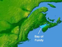
The Bay of Fundy (French: Baie de Fundy) is a bay between the Canadian provinces of New Brunswick and Nova Scotia, with a small portion touching the U.S. state of Maine. It is an arm of the Gulf of Maine. Its tidal range is the highest in the world.[2]
The bay was named Bakudabakek by the indigenous Mi'kmaq and Passamaquoddy groups, meaning "open way". The Wolastoqiyik peoples named it Wekwabegituk, meaning "waves at the head of the bay".[3] The name "Fundy" has been speculated to have derived from the French word fendu ("split")[4] or Fond de la Baie ("head of the bay"). Some individuals have disputed this, including William Francis Ganong, who suggested that the name likely derived from Portuguese origin instead, specifically regarding João Álvares Fagundes, who may have referred to the bay as Gram Baya ("Great Bay") and nearby waters as Rio Fondo ("deep river").[3]
- ^ a b "Bay of Fundy". Encyclopædia Britannica. April 16, 2025. Retrieved April 18, 2025.
- ^ National Ocean Service,
- ^ a b "What Does "Fundy" Mean?". Backyard History. June 17, 2022. Retrieved April 24, 2025.
- ^ Garrett, Chris; Koslow, Tony; Singh, Rabindra (March 25, 2015) [July 8, 2010]. "Fundy, Bay of and Gulf of Maine". The Canadian Encyclopedia (online ed.). Historica Canada.
© MMXXIII Rich X Search. We shall prevail. All rights reserved. Rich X Search
