| Balch Creek | |
|---|---|
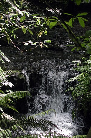
 Waterfall in Macleay Park | |
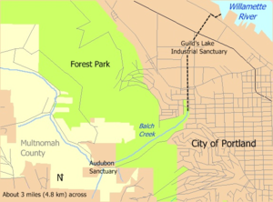
 Balch Creek in Portland and unincorporated Multnomah County. Dashed black line shows stream course through storm sewer.[1] | |
| Etymology | Danford Balch, early settler |
| Location | |
| Country | United States |
| State | Oregon |
| County | Multnomah |
| Physical characteristics | |
| Source | Tualatin Mountains (West Hills) |
| • location | Portland, Multnomah County, Oregon |
| • coordinates | 45°32′34″N 122°45′35″W / 45.54278°N 122.75972°W[2] |
| • elevation | 1,116 ft (340 m)[3] |
| Mouth | Willamette River |
• location | Portland, Multnomah County, Oregon |
• coordinates | 45°32′16″N 122°42′41″W / 45.53778°N 122.71139°W[2] |
• elevation | 46 ft (14 m)[2] |
| Length | 3.5 mi (5.6 km)[4] |
| Basin size | 3.5 sq mi (9.1 km2)[5] |
| Discharge | |
| • location | Lower Macleay Park[6][7] |
| • average | 1.05 cu ft/s (0.030 m3/s)[6][7] |
| • minimum | 0 cu ft/s (0 m3/s) |
| • maximum | 73 cu ft/s (2.1 m3/s) |
Balch Creek is a 3.5-mile (5.6 km) tributary of the Willamette River in the U.S. state of Oregon. Beginning at the crest of the Tualatin Mountains (West Hills), the creek flows generally east down a canyon along Northwest Cornell Road in unincorporated Multnomah County and through the Macleay Park section of Forest Park, a large municipal park in Portland. At the lower end of the park, the stream enters a pipe and remains underground until reaching the river. Danford Balch, after whom the creek is named, settled a land claim along the creek in the mid-19th century. After murdering his son-in-law, he became the first person legally hanged in Oregon.
Basalt, mostly covered by silt in the uplands and sediment in the lowlands, underlies the Balch Creek watershed. The upper part of the watershed includes private residential land, the Audubon Society of Portland nature sanctuary, and part of Forest Park. Mixed conifer forest of Coast Douglas-fir, western redcedar, and western hemlock with a well-developed understory of shrubs and flowering plants is the natural vegetation. Sixty-two species of mammals and more than 112 species of birds use Forest Park. A small population of coastal cutthroat trout resides in the stream, which in 2005 was the only major water body in Portland that met state standards for bacteria, temperature, and dissolved oxygen.
Although nature reserves cover much of the upper and middle parts of the watershed, industrial sites dominate the lower part. Historic Guild's Lake occupied part of the lower watershed through the 19th century, and in 1905 city officials held the Lewis and Clark Centennial Exposition there on an artificial island. After the exposition, developers converted the lake and its surrounds to industrial use, and in 2001 the Portland City Council declared the site to be an "industrial sanctuary".
- ^ Bureau of Environmental Services (2008). "Northwest District Sewer Assets". Portland Maps. City of Portland. Retrieved July 3, 2008.
- ^ a b c "Balch Creek". Geographic Names Information System (GNIS). United States Geological Survey (USGS). October 22, 1999. Retrieved May 5, 2008.
- ^ Source elevation derived from Google Earth search using GNIS source coordinates.
- ^ Cite error: The named reference
streetmapwas invoked but never defined (see the help page). - ^ Cite error: The named reference
zoningwas invoked but never defined (see the help page). - ^ a b Cite error: The named reference
flowwas invoked but never defined (see the help page). - ^ a b The average annual flow was derived by adding the average summer flow given by the Portland Bureau of Environmental Services to the average winter flow and dividing by 2.
© MMXXIII Rich X Search. We shall prevail. All rights reserved. Rich X Search

