Back ألامو (كاليفورنيا) Arabic آلامو، کالیفورنیا AZB Аламо (Калифорния) Bulgarian Alamo (Califòrnia) Catalan Аламо (Калифорни) CE Alamo (lungsod sa Tinipong Bansa, California) CEB Alamo (Kalifornien) German Alamo (Kalifornio) Esperanto Álamo (California) Spanish Alamo (Kalifornia) Basque
Alamo | |
|---|---|
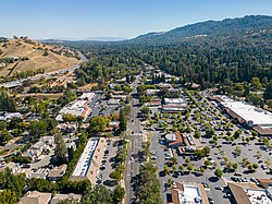
 Downtown Alamo | |
 Location in Contra Costa County and the state of California | |
| Coordinates: 37°51′01″N 122°01′56″W / 37.85028°N 122.03222°W | |
| Country | |
| State | |
| County | Contra Costa |
| Government | |
| • State Senator | Steve Glazer (D)[1] |
| • State Assembly | Rebecca Bauer-Kahan (D)[2] |
| • U. S. Congress | Mark DeSaulnier[3] |
| Area | |
| • Total | 9.82 sq mi (25.42 km2) |
| • Land | 9.82 sq mi (25.42 km2) |
| • Water | 0.00 sq mi (0.00 km2) 0% |
| Elevation | 259 ft (79 m) |
| Population (2020) | |
| • Total | 15,314 |
| • Density | 1,560.11/sq mi (602.38/km2) |
| Time zone | UTC-8 (PST) |
| • Summer (DST) | UTC-7 (PDT) |
| ZIP code | 94507 |
| Area code | 925 |
| FIPS code | 06-00618 |
| GNIS feature IDs | 1657900, 2407707 |
Alamo (Spanish: Álamo; meaning "Poplar tree") is an unincorporated community and census-designated place (CDP) in Contra Costa County, California, in the United States. It is a suburb located in the San Francisco Bay Area's East Bay region, approximately 28 miles (45 km) east of San Francisco.[5] Alamo is equidistant from the city of Walnut Creek and the incorporated town of Danville. As of the 2020 census, the population was 15,314.
Police services are provided by the Contra Costa County Office of the Sheriff. Fire and EMS services are provided by the San Ramon Valley Fire Protection District.
Alamo has a median household income of $250,000 (as of 2022[update]).[6] The average home price in Alamo is $2,400,000[7] (as of January 2024). In August 2007, a group of citizens launched a new initiative to incorporate the community,[8] the latest in a series of attempts that go back to the early 1960s or before; it was defeated by referendum in March 2009.[9] Previous failed Alamo incorporation efforts always included parts of other nearby unincorporated areas: Alamo-Danville (1964)[10] and Alamo-Danville-San Ramon (1976).[10][11]
- ^ "Senators". State of California. Retrieved March 28, 2013.
- ^ "Members Assembly". State of California. Retrieved March 28, 2013.
- ^ https://www.govtrack.us/congress/members/CA/10
- ^ "2020 U.S. Gazetteer Files". United States Census Bureau. Retrieved October 30, 2021.
- ^ "Map of Alamo, CA and San Francisco, CA".
- ^ https://www.census.gov/quickfacts/fact/table/alamocdpcalifornia,templetoncdpcalifornia,mayflowervillagecdpcalifornia,cerritoscitycalifornia,springvalleycdpcalifornia/PST045222
- ^ https://www.redfin.com/city/21136/CA/Alamo/housing-market
- ^ Benca, Jeanine (August 6, 2007). "Residents of Alamo begin path to cityhood". East Bay Times. Retrieved April 6, 2019.
- ^ "Incorporation's end". Danville Express. Danvilleweekly.com. March 6, 2009. Archived from the original on February 18, 2010. Retrieved November 2, 2013.
- ^ a b Museum of the San Ramon Valley. "Museum of the San Ramon Valley|History|Home Rule II". Museumsrv.org. Archived from the original on November 3, 2013. Retrieved November 2, 2013.
- ^ Museum of the San Ramon Valley (June 8, 1982). "Museum of the San Ramon Valley|History|Home Rule III". Museumsrv.org. Archived from the original on November 3, 2013. Retrieved November 2, 2013.
© MMXXIII Rich X Search. We shall prevail. All rights reserved. Rich X Search
